USFWS, State Release EIS For Tijuana Estuary Tidal Restoration Project
The following is courtesy of the U.S. Fish and Wildlife Service’s Pacific Southwest Region:

Final Environmental Impact Report/Environmental Impact Statement
The U.S. Fish and Wildlife Service (USFWS) and California Department of Parks and Recreation (CA State Parks), announce the availability of the Final Environmental Impact Report/Environmental Impact Statement (FEIR/EIS) for the Tijuana Estuary Tidal Restoration Program II Phase I l (TETRP II Phase I). To review the FEIR/EIS, go to: https://trnerr.org/about/public-notices/.
This important milestone moves us another step closer to restoring 82 to 87 acres of coastal wetlands and associated native uplands within the southwestern portion of the Tijuana Estuary, located in San Diego County, California (Figure 1).
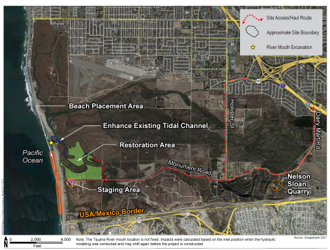
TETRP II Phase I is a multi-agency effort to improve habitat quality within the Tijuana Estuary. Project partners include California State Parks, USFWS, Tijuana River National Estuarine Research Reserve (TRNERR), Southwest Wetlands Interpretive Association, and the U.S. Army Corps of Engineers (Corps) (a cooperating agency for the EIS process), as well as the joint planning and funding partners, the California State Coastal Conservancy and California Wildlife Conservation Board.
Project History
Restoration planning for the lands located within and adjacent to the Tijuana Estuary was initiated in the late 1980s. The results of this early planning include the restoration of the Model Marsh, located adjacent to the current project boundary, as well as the very successful Connector Channel restoration, which restored essential tidal circulation in the northern arm of the estuary. The current proposal, TETRP II Phase I, proposes to restore additional coastal salt marsh and native upland habitat around the Model Marsh.
Environmental Planning and Analysis
The feasibility of restoring additional coastal wetlands around the Model Marsh began around 2003 and resulted in a proposal to restore another 80 to 90 acres of native wetland and upland habitat within the estuary. Also evaluated was the need to ensure that the Tijuana River inlet/outlet to the Pacific Ocean remained open to protect the quality of the wetland habitat with the estuary.
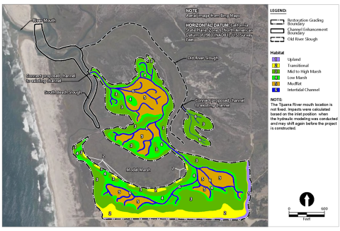
Based on these prior recommendations, two restoration alternatives and a no project alternative were identified for analysis. Alternative 1 (Figure 2) proposes a restoration footprint of approximately 87 acres, and was designed to maximize deeper intertidal habitats, such as mudflat, to increase tidal prism in the southern arm of the estuary.
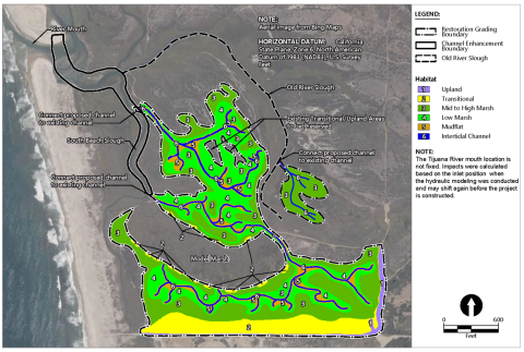
Alternative 2, identified as the Proposed Project in the EIR/EIS, proposes a restoration footprint of approximately 82.5 acres of native habitat, including 62.8 acres of intertidal wetlands, 5.1 acres of intertidal channel, and 14.6 acres of native transitional and upland habitat (Figure 3). This alternative emphasizes the restoration of low and mid- to high salt marsh habitat, with only limited areas restored to intertidal mudflat. This alternative, with its slightly smaller restoration footprint avoids areas of transitional and native upland plant communities that would be restored to wetlands under Alternative 1.
Also evaluated was the no project alternative, which would result in no changes to the current conditions within the southwestern portion of the Tijuana River Valley.
A description of these restoration alternatives and the associated environmental effects of implementing them, along with an analysis of the no project alternative, is provided in the FEIR/EIS, which is available for review at: https://trnerr.org/about/public-notices/.
To review a printed copy of the FEIR/EIS, visit the Tijuana Estuary Visitor Center at 301 Caspian Way, Imperial Beach, CA 91932, telephone 619-575-3613. The Visitor Center is open Wednesday – Sunday, 10:00 a.m. – 5:00 p.m. (but you are advised to call first to verify office hours).
Environmental Review Process
The USFWS and CA State Parks, as the respective lead agency under the National Environmental Policy Act and the California Environmental Quality Act, issued a Notice of Intent to prepare a draft EIR/EIS for the TETRP II Phase I project on May 27, 2021.
The Notice of Availability of the draft EIR/EIS was published in the Federal Register on August 19, 2022. A 45-day review period was provided for the public and agencies to review the draft EIR/EIS and provide comments. Two virtual public meetings were held on September 8, 2022.
Six comment letters were received during the public comment period. Commenters included the Environmental Protection Agency, California Department of Fish and Wildlife, County of San Diego, San Diego Audubon Society, and two members of the public. In accordance with 40 CFR §1502.17(b), Chapter 8 of the FEIR/EIS includes a summary presenting all alternatives, information, and analyses submitted by State, Tribal, and local governments, and other public commenters for consideration by the lead and cooperating agencies in developing the FEIS/EIR. Some changes were made to the text of the EIR/EIS in response to the comments. The comment letters and responses to those comments are provided in Appendix D of the FEIR/EIS.
The Notice of Availability (NOA) of the FEIS was published in the Federal Register on March 31, 2023. The USFWS will issue a Record of Decision no sooner than 30 days after the date of publication of the NOA in the Federal Register.
For More Information
For questions or other information, please contact Victoria Touchstone, Conservation Planner, at Victoria_Touchstone@fws.gov or leave a message at 760-431-9440 extension 273 and your call will be returned.
Project Partners