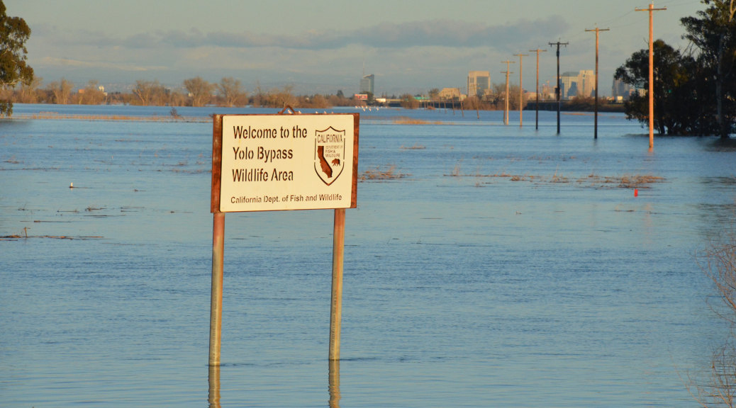
Flooding Causing Havoc For Sacramento-Area Wildlife Areas

The following press release is courtesy of the California Department of Fish and Wildlife:
Recent flooding has limited opportunities for nature enthusiasts, hunters and students to enjoy certain wildlife areas and ecological reserves operated by the California Department of Fish and Wildlife (CDFW).
The Yolo Bypass Wildlife Area just west of Sacramento completely flooded in January, leading to the temporary closure of the wildlife area and affecting more than 200 hunters and other visitors each day. The closures also affected school nature programs – which serve more than 4,000 students annually at Yolo Bypass Wildlife Area alone – necessitating the postponement or cancellation of scheduled trips to the wildlife observation drive.
Nearby, the Fremont Weir Wildlife Area automatically starts to flood when the Sacramento River reaches the height of the weir. Such flooding has occurred several times this winter and the trend is expected to continue. Access to the wildlife area is restricted when the river is rising or water is flowing across the fields. After a heavy rain, the access road can be muddy and four-wheel-drive vehicles may be needed.
At Upper Butte Basin Wildlife Area, 100 miles north of Sacramento near Gridley, all three units were closed to hunting. At Colusa and Delevan National Wildlife Refuges, hunting programs were severely reduced for the last two weeks of waterfowl season. The entire Grizzly Island Wildlife Area complex southwest of Fairfield is also closed due to water spilling over levees.
In Merced County, the entire floodplain of the China Island Unit of North Grasslands Wildlife Area along the San Joaquin River was inundated. The area remained open to waterfowl hunting but required a boat to access the floodplain.
In Southern California, San Jacinto Wildlife Area in western Riverside County experienced heavy rains that compromised Davis Road. This area remains flooded and accessible only by four-wheel-drive vehicles. The county will be launching efforts to make it passable in the coming months.
“Periodically, flood conditions will affect public use of the wildlife areas and other lands CDFW manages,” said CDFW Lands Program Manager Kari Lewis. “After many years of drought, the recent rains remind us how quickly the amount of water on the landscape can change, affecting the accessibility of these areas for hunting and wildlife viewing.”
In the short term, many of the closures are inconvenient, but are nonetheless necessary for public safety and to provide safe haven and minimize stress to displaced wildlife. In the long term, the benefit of the rain is indisputable. Floodwaters at Yolo Bypass Wildlife Area, for instance, will cause rice grains to float out of the stubble – providing ready food for migrating waterfowl, new mudflats for shorebirds to feed on.
Statewide, CDFW manages more than a million acres for wildlife, which together see more than a million visitors a year. These lands support recreational pursuits such as bird watching and wildlife viewing, rare plant study and fishing and hunting opportunities. Individual properties support different suites of species, such as Elkhorn Slough National Estuarine Research Reserve, a coastal wetland that provides invaluable habitat for wildlife including sea otters, brown pelicans and bat rays, and Gray Lodge Wildlife Area in the Central Valley, which hosts more than a million migrating waterfowl annually. All of these lands are vital to the state’s efforts to preserve California’s ecological heritage and provide the public with opportunities to enjoy these resources.
“Farsighted conservationists with what was then called the California Department of Fish and Game began purchasing key wildlands in the 1920s to ensure the future of California’s wildlife,” said CDFW Director Charlton H. Bonham. “It is our job to wisely preserve, manage and protect these jewels of conservation in times of both drought and floods.”
Current information about CDFW wildlife area closures can be found at https://nrm.dfg.ca.gov/FileHandler.ashx?DocumentID=57660&inline or via Twitter tag #cawildlifeareaclosures. Additional information about CDFW lands can also be found at www.wildlife.ca.gov/lands.
Limited funding to maintain and operate these lands comes primarily from hunting license sales and federal grants programs such as those created under the federal Wildlife Restoration Act.


